Recent searches
Search options

#seismology

 Hacker News
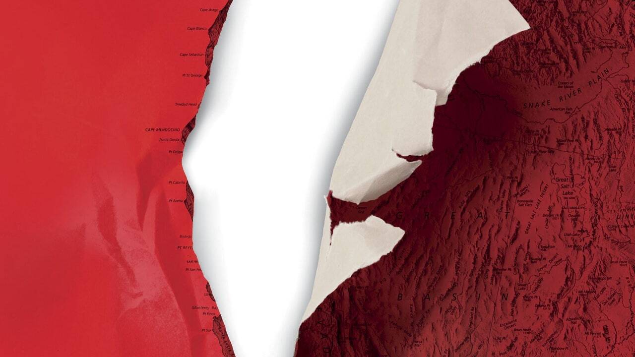

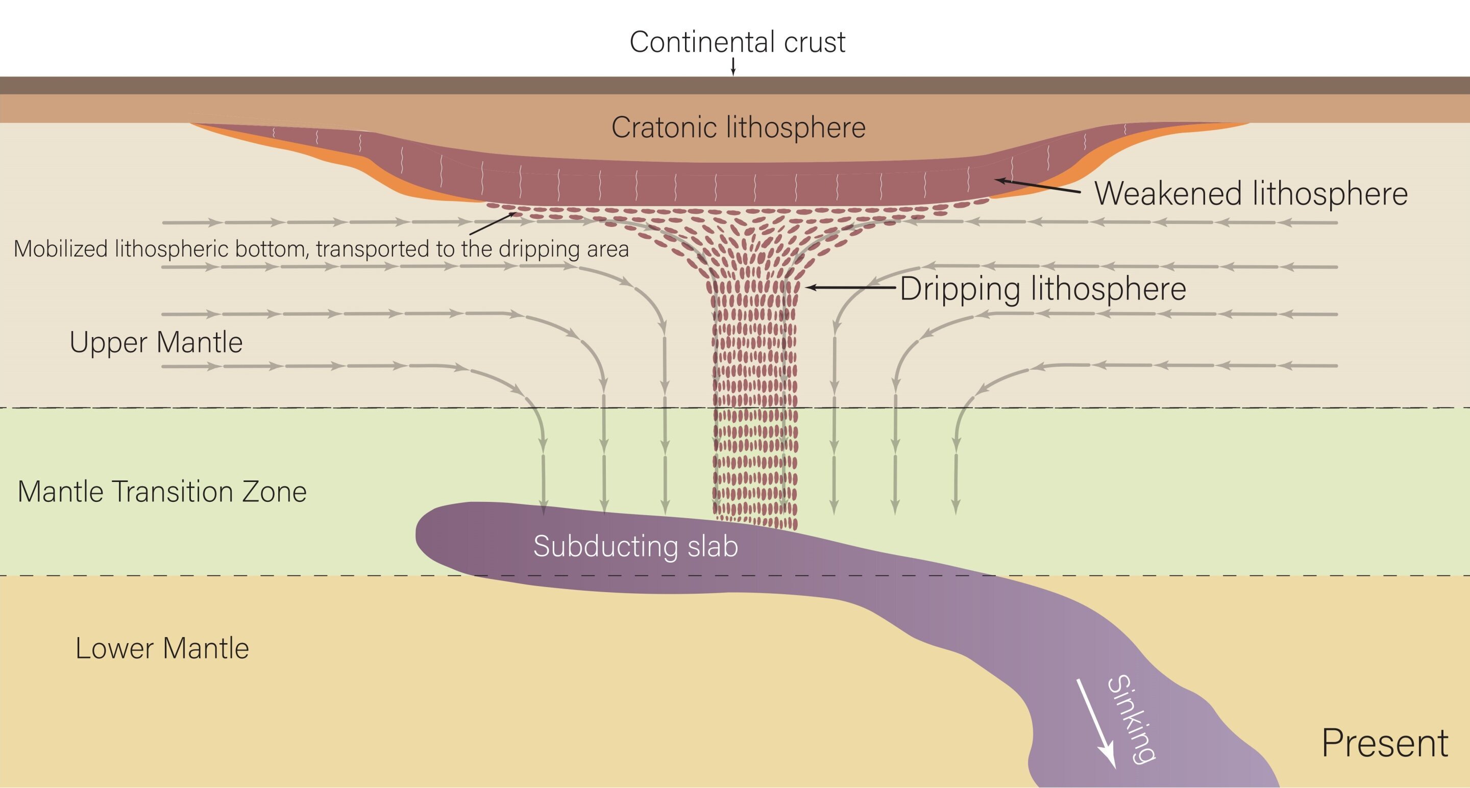
Someone, call Mario! We've sprung a leak!
#NorthAmerica is dripping from below, #geoscientists discover https://buff.ly/M7CXKiF

Who doesn't like a two-fer?
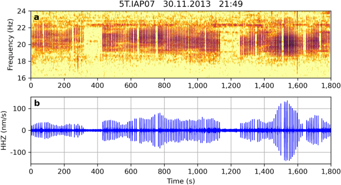
"In this feasibility study we investigate if vocalising near-coastal fin whales can be widely detected and located with onshore seismometers... we establish that fin whale song can be detected with onshore seismometers up to 5.5 km inland, across multiple marine environments, globally. Individual creatures can be located and tracked through the analysis of seismic wave properties."
#RPi Easter Egg therein.
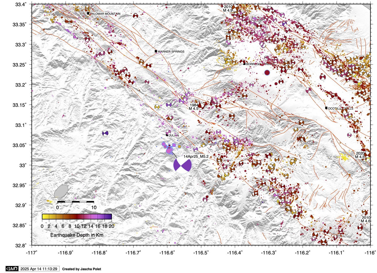
Map of today’s M5.2 #earthquake near Julian in the context of regional past seismicity. This event was located near the Elsinore #fault and relatively deep at 18 km.
#julian #california #geoscience #seismology #tectonics

Scientists puzzled by Earth's 'heartbeat' that causes slight tremors every 26 seconds
All explanations including ocean waves, volcanoes, and fractured sediments have been ruled out, leaving the mystery behind seismic tremors every 26 seconds unsolved.


We are looking for a PhD student to work at ISTerre (Grenoble, France) on tiny seismic waves generated by the ocean with physics, numerical modeling and signal processing.
Feel free to DM me for details. Please boost <3
#getfedihired #physics #seismology


USGS: M 7.1 Earthquake – 90 km SE of Pangai, Tonga
https://earthquake.usgs.gov/earthquakes/eventpage/us7000pntq/executive
#HackerNews #USGS #Earthquake #Tonga #M7.1 #NaturalDisaster #Seismology #EmergencyResponse

Time lapse of seismic waves traveling through Europe from the Myanmar earthquake, 7.7 Richter
[red shows uplift, blue shows lowering]

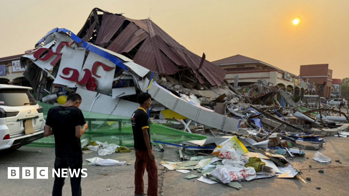
#Myanmar and #Thailand earthquake live updates: Hundreds feared dead, with 81 trapped in collapsed #Bangkok building - BBC News
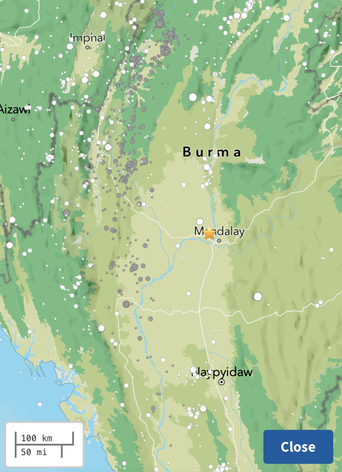
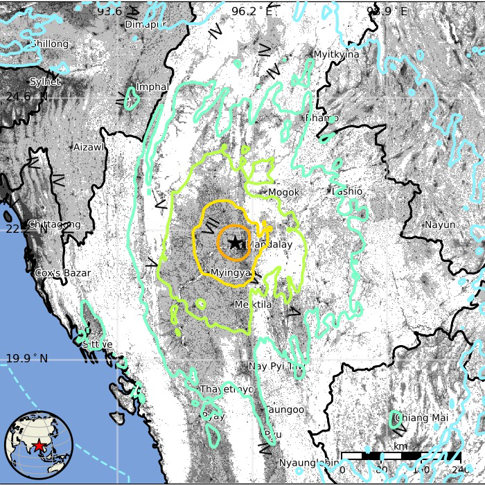
A comparison of the Sagaing fault map that shows historic earthquake rupture lengths with the USGS slip model of today’s M7.7 #earthquake in Myanmar suggests today’s event may have ruptured the northern half of the 1839 earthquake fault patch.
#myanmar #geoscience #seismology #geology


A historical seismicity map shows several #earthquakes of similar size to today’s M7.7 in Myanmar occurred in the region in the early 20th century, but this section of the Sagaing fault probably hasn’t ruptured since 1839
#geoscience #seismology #myanmar

This is just speculation on my part at the moment, but maybe the deep basin under Bangkok could have caused a seismic resonance of the surface waves from the M7.7 Myanmar #earthquake?
In a manner similar to the resonance in Mexico City due to subduction earthquakes at significant distance.
#seismology #geology
https://geoenvironmental-disasters.springeropen.com/articles/10.1186/s40677-023-00259-0
M7.7 shallow strike slip #earthquake in Myanmar that occurred two hours ago has red PAGER estimates for fatalities and economic losses and is located near the city of Mandalay #geoscience #seismology
https://earthquake.usgs.gov/earthquakes/eventpage/us7000pn9s/pager

Slipping Ice Streams
The Northeast Greenland Ice Stream provides about 12% of the island’s annual ice discharge, and so far, models cannot accurately capture just how quickly the ice moves. Researchers deployed a fiber-optic cable into a borehole and set explosive charges on the ice to capture images of its interior through seismology. But in the process, they measured seismic events that didn’t correspond to the team’s charges.
Instead, the researchers identified the signals as small, cascading icequakes that were undetectable from the surface. The quakes were signs of ice locally sticking and slipping — a failure mode that current models don’t capture. Moreover, the team was able to isolate each event to distinct layers of the ice, all of which corresponded to ice strata affected by volcanic ash (note the dark streak in the ice core image above). Whenever a volcanic eruption spread ash on the ice, it created a weaker layer. Even after hundreds more meters of ice have formed atop these weaker layers, the ice still breaks first in those layers, which may account for the ice stream’s higher-than-predicted flow. (Image credit: L. Warzecha/LWimages; research credit: A. Fichtner et al.; via Eos)

Some scientists here in the #PNW report on how the wires connecting us to safety are being yanked by greedy morons.

Trinidad & Tobago Express Newspapers: What’s happening at the Piparo Volcano?…
The University of the West Indies (UWI) has set up instruments at the site of the Piparo mud volcano to monitor volcanic activity, as residents continue to complain of rumblings from the vents close to their homes... #mudvolcano #trinidadandtobago #UWI #seismology


Naples residents camp outdoors after an overnight earthquake.
Many people in and around the Italian city of Naples have spent the night on the streets and in their cars after an earthquake shook buildings and brought rubble crashing down.
Italian seismologists said the 4.4 magnitude tremor struck at 01:25 local time on Thursday at a shallow depth of three kilometres. The US Geological Survey measured it as a 4.2 tremor 10km deep.
