Continued thread
Wow, major dust storm visible on satellite in southern NM today. Stay off the roads, folks! 4/27/25 1823MT #NMwx #duststorm #dust
GIF

Wow, major dust storm visible on satellite in southern NM today. Stay off the roads, folks! 4/27/25 1823MT #NMwx #duststorm #dust
Wow, serious dust storm in New Mexico (again) 4/27/25 1822MT #duststorm #NMwx

It was a dynamic weather day in New Mexico.
This weather satellite loop shows us a variety of activity:
- overall west-to-east flow of dry air in the western half of New Mexico. This dry air is not very dusty, at least not initially.
- moist air over the eastern half, which tends to be hazier. This haziness is seen best near the end of the loop when the sun angle gets low.
- strong thunderstorms developing along the dry line
- outflows and gust fronts from the storms raising dust and pushing it east against the flow of the dry air
- strong breezes in northeast Sonora, Mexico boost fire activity. The bluish smoke plume becomes visible near the end of the loop. The strong breezes also pick up dust at the end of the loop...colored tan/brown
- the moist air can't push further west because the terrain gets higher.
This is a follow up to an earlier post/toot about the Dry Line weather system:
https://universeodon.com/@KrajciTom/114406001338553756
A dust storm is kicked up by low-level outflow that races ahead of a cold front in southern New Mexico...reaching deep into west Texas and crossing all of southeast New Mexico by sunset.
This is an animation loop from visible light weather satellite images, overlayed with county boundaries and highways.
This is a follow up to:
https://universeodon.com/@KrajciTom/114366800523414859
A localized dust storm is kicked up by low-level outflow that races ahead of a cold front in southern New Mexico.
This is an animation loop from visible light weather satellite images, overlayed with composite radar, 500mb isobars and wind barbs, and county boundaries and highways.
The screengrab is annotated to show the direction of motion and the low-level outflow boundary that kicks up lots of desert dust. (This screengrab is taken from one of the later frames in the animation loop.)
You probably have to watch the loop more than once to see the subtle initial appearance of the low-level outflow boundary and dust...that becomes all too obvious by the end of the animation loop.
[Edit/add: METAR history (final screengrab) for Alamogordo showing how visibility went to hell as the outflow and dust storm moved into the area.


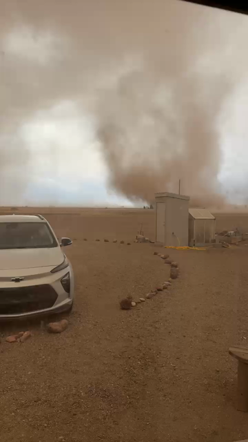
Serious dust storm conditions in New Mexico right now. 4/17/25 2025 #NMwx #duststorm #Haboob

Dust Storms return to Southern New Mexico. 4/17/25 1419 MT #duststorm #NMwx
Dust storm over the Persian Gulf on Sentinel-3 h/t Kosmi on Bsky
#climatemergency #iraq #duststorm #dust

Animated view of dust storms today 4/1/25 in New Mexico and Texas. #NMwx #TXwx #duststorm
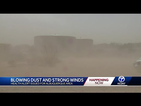
KOAT: Health officials warn of respiratory risks with blowing dust
https://www.koat.com/article/state-warns-of-potential-health-risk-from-dust-storm/64345319
Dust storm in southern New Mexico. Not an April Fools joke.
Many highways closed due to zero visibility.


Droughts are increasing. Global warning dries out continents, increases coastal formed storms. Canada's forests burning, farms failing, dust storms growing.
Map of U.S. droughts

Last night's dust storm over New Mexico continued to rage through the night, and sunrise shows it has reached Louisiana, Arkansas, and other states to the north of them. (See screenshot - dust storm is highlighted with red dots.)
This is a follow up to yesterday's toot/post: https://universeodon.com/@KrajciTom/114187160615114653

Dust storm and many wind driven fires in the southwest US. Same song, 22nd verse.
One fire is about a half hour drive from me:
https://app.watchduty.org/i/44174
"Emergency personnel were juggling road closures due to dust storms and high winds—San Augustin Pass, just east of Las Cruces, reported a gust at 93 mph.
US Highway 54 was briefly closed from the southern Otero County line near El Paso to the northern Otero County and Lincoln County lines due to high winds, blowing dust and vehicle wrecks. Crews could be heard over the radio leaving an accident on Highway 54 to head towards the Mayhill-adjacent fire.
The Otero County Electric Cooperative (OCEC) reported dozens of outages affecting thousands of customers from Timberon to Carrizozo. Line crews are working on restoring power to the affected areas."
https://www.cloudcroftreader.com/p/gail-fire-near-mayhill-new-mexico


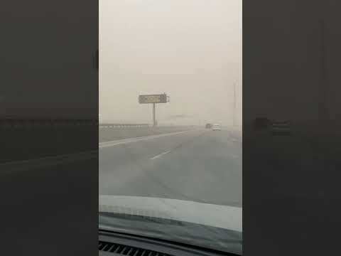
Okay, these people should NOT BE DRIVING in a zero visibility dust storm. This is how you get massive pileups. #duststorm #dust #NMwx https://www.youtube.com/watch?v=Q3cz8xPYBfo

Hmm, apparently my bot was not lying about the name of that Texas city. Which was duly hashtagged. Hoping that is not leading people astray. 
Stay safe, everyone! #TXwx #duststorm